Prepare early as cyclone approaches
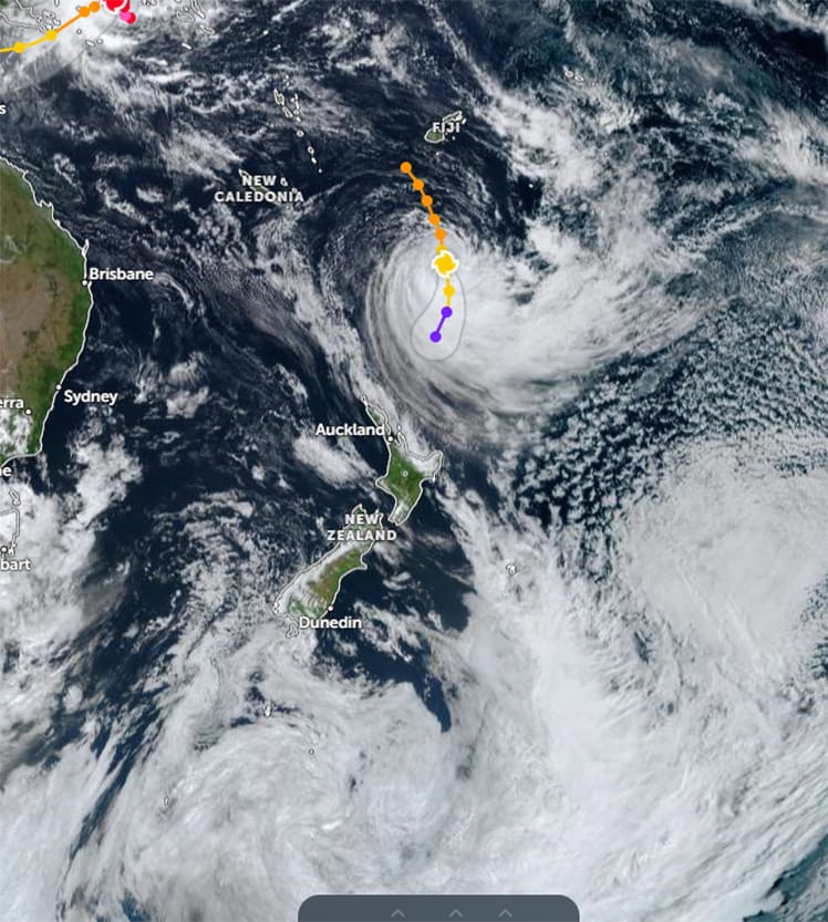
ON THE WAY: A satellite image of Cyclone Vaianu being tracked by MetService yesterday.
.
Cyclone Vaianu, a Category 2 storm forecast to begin impacting parts of the country from early Sunday morning, is being closely monitored by Whakatāne District Council.
Emergency response planning has been activated, with the Council working alongside MetService New Zealand and partner agencies to track the system and prepare for potential impacts, the council says.
Whakatāne District Local Controller Nicholas Woodley said although there was still uncertainty around the cyclone’s exact path, the message is clear: prepare now.
“This is a system we are taking very seriously,” said Mr Woodley.
“While we can’t yet say exactly what impacts we will see locally, there is enough uncertainty and potential risk – particularly around coastal surge and heavy rainfall – that people should be preparing now rather than waiting.”
Council crews are already responding to the effects of more than 24 hours of heavy rain, including surface flooding, downed trees and localised road issues.
With ground conditions saturated, the risk of slips and landslides is heightened, especially in steep or vulnerable areas.
“We are dealing with two things at once,” said Mr Woodley. “There’s the immediate impact of the current wet weather, and the need to plan ahead for what Cyclone Vaianu could bring on top of that. That combination increases the likelihood of impacts escalating quickly.”
Mr Woodley said now was the time to make practical preparations.
“We know how quickly weather impacts can escalate in this district. Preparing early – securing loose items, planning for possible power outages, and thinking about what you would do if access became limited – helps avoid rushed decisions later.”
Although no evacuations are required at this stage, the council is encouraging residents, particularly those in coastal areas – or anyone who feels unsafe – to make early arrangements to stay with friends or family if needed.
“Cyclone conditions are currently forecast to arrive around 3am Sunday. No one wants to be evacuating in the dark, in severe weather,” said Mr Woodley.
“If you have concerns about your safety, the safest option is to move early, ideally before Saturday night, and stay with friends or whānau.”
If evacuations become necessary, they will be led by police, with affected properties door knocked directly.
People are also urged to stay well clear of beaches, river mouths and coastal areas, where conditions can become unpredictable very quickly.
If required, a welfare centre will be activated at the Whakatāne War Memorial Hall, and potentially other locations if needed, with clear instructions provided at the time.
Residents who notice issues such as flooding, slips, fallen trees or road damage are asked to report them through the correct channels so they can be triaged and responded to quickly:
n Urgent issues: Call council’s 24/7 call centre on 07 306 0500
n Non-urgent issues: Log them using the Fix It and Report a Problem form on the council’s website.
The council will continue operating in a heightened monitoring mode and will provide clear, factual updates through its website, Facebook page, and local radio as the situation develops.
“Our priority is keeping our communities safe and well informed,” said Mr Woodley.
“Prepared beats panicked. This is about being ready, not being alarmed.”

Cyclone Vaianu – widespread impacts
Aston Palmer
Category two tropical cyclone Vaianu is expected to reach New Zealand early on Sunday.
Metservice Meteorologist Alanna Burrows told the Beacon they could not pinpoint exactly where in the North Island the cyclone would first hit, but they had forecast that it would affect most of the North Island, including Whakatāne and the wider Eastern Bay.
“We are expecting widespread impacts with very strong winds, which could possibly be life-threatening,” said Ms Burrows.
A widespread yellow strong wind and heavy rain warning is in place across the whole of the North Island, which Metservice will update.
Ms Burrows said the strong wind and heavy rain watch starts at 4am on Sunday with the heavy rain warning expected to last late into Sunday night and strong wind warning to last until 1am on Monday.
The heavy rain over the past few days in the Whakatāne region is a separate weather event to the cyclone but could increase the possibility of roads flooding and rivers and reservoirs overflowing.
Metservice advises that people cancel plans and tie down any loose objects, and to check on friends, family and neighbours this Sunday.
It suggests to keep an eye on the weather warnings and cyclone updates on the Metservice website and Facebook page: https://www.facebook.com/MetService and www.facebook.com/MetService