Updated tsunami evacuation maps now available for BOP
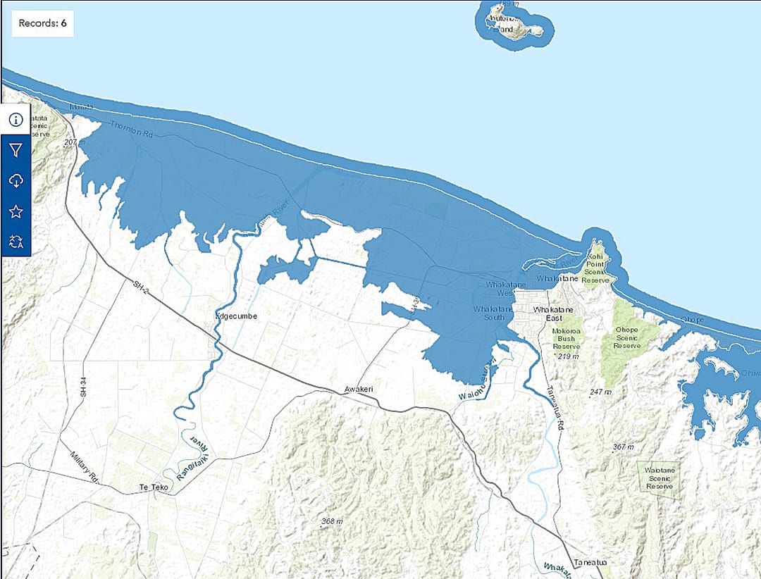
EVACUATE: The blue tsunami evacuation zone marks the area people should evacuate from in the event of a long or strong earthquake or a tsunami warning. Photo supplied
.
Updated tsunami evacuation maps are available for those in Bay of Plenty coastal areas.
The revised maps – detailing “blue zones” that should be evacuated from in a tsunami event - are based on updated computer modelling and data from Earth Sciences New Zealand (formerly GNS Science) that predicts how far inland tsunami waves could reach, depending on their size and source.
With this data, the Bay of Plenty Regional Council and Emergency Management Bay of Plenty have worked alongside local councils across the rohe (region) to create tsunami evacuation zones for communities that also consider aspects such as evacuation constraints, practicalities and safety, roading, population density and social factors.
In 2023, tsunami evacuation maps across the region shifted from red-orange-yellow zones that reflected different tsunami scenarios, to a singular “blue zone” to make it much easier to know who needed to evacuate and where to evacuate to.
“Now, thanks to the new modelling and data, we’re able to update the evacuation zones within the regional maps.
“Some areas have changed quite a bit while in other areas the zone has only had some minor changes. We encourage everyone to check the new evacuation maps to see if there have been changes in their area.
“Evacuation zones consider a range of aspects including data from recent tsunami modelling.
“Tsunami modelling was conducted using the latest technology and available data for the region, to ensure we have the most up-to-date information.
As well as tsunami modelling, evacuation zones also consider other aspects such as evacuation constraints, practicalities and safety, roading, population density and social factors.
There are over 150 signboards detailing tsunami evacuation information across coastal Bay of Plenty.
The signboards have been updated from this week. Digital maps are available now on the Bay of Plenty Civil Defence website, alongside local council websites.
Tsunami evacuation zone maps show where people should go to be safe during a tsunami, and the areas people need to move out of if there’s a tsunami warning.
Emergency Management Bay of Plenty regional manager Jono Gracie encourages everyone to view the relevant tsunami evacuation maps for their area as part of the household evacuation plan and ensure they’re regularly practicing their plan/tsunami hikoi evacuation route.
“Any means of evacuation that does not contribute to traffic congestion should be considered, including walking or cycling if you can.
“In the event of a big tsunami generated near our coastline, there might not be time for official warnings before the first wave hits – that’s why we say, ‘long or strong, get gone’ and why people should act immediately and not wait for official warnings.
“Natural warning signs of a tsunami, alongside a long or strong earthquake include sudden changes in sea level, or unusual noises, like a jet plane, coming from the ocean.”