A new eruptive episode at Whakaari/White Island
.
■ With Whakaari/White Island erupting on and off since May 2024, GeoNet has taken a deeper dive into recent activity and summarised the information provided in its Volcanic Activity Bulletins
Whakaari/White Island is the most active volcano in New Zealand and has been since the 1970s. Rather than just producing single eruptions, Whakaari/White Island has moved in and out of eruptive episodes over the years.
In May 2024, a new eruptive episode started, which has included elevated unrest and several weak eruptions.
Eruptive episodes are how scientists describe clusters of closely spaced eruptions that are linked by a common process, such as magma moving to shallower levels under the volcano.
The higher gas output and heat from the shallow magma is driving the recent eruptions and ash emission at Whakaari/White Island.
Other eruptions in the past 15 years have been linked to similar processes and gas pressure build-up and release, as in 2012-2013, 2016, and 2019.
■ When volcanic activity changes
GeoNet’s Volcano Monitoring Group – a group of multi-disciplinary scientists operating as the national volcano observatory – keeps tabs on New Zealand’s active volcanoes and determines their level of activity.
The group assigns a Volcanic Alert Level (VAL) to each volcano, which communicates the current level of volcanic unrest or eruptive activity. During the current eruptive episode at Whakaari/White Island, the volcano has moved up and down between Levels 2 and 3.
VAL 2 is moderate-to-heightened volcanic unrest, and VAL 3 is minor volcanic eruption.
For some time, the lack of real-time monitoring data from the island has meant scientists cannot distinguish between Volcanic Alert Level 1 and 2.
Because of this, the monitoring group has fixed the alert level at Whakaari/White Island to a minimum of Level 2 until on-island monitoring is reinstated.
The below graph shows what the Volcanic Alert Level has been since May 2024, and when there have been eruptions and periods of minor ash emission.
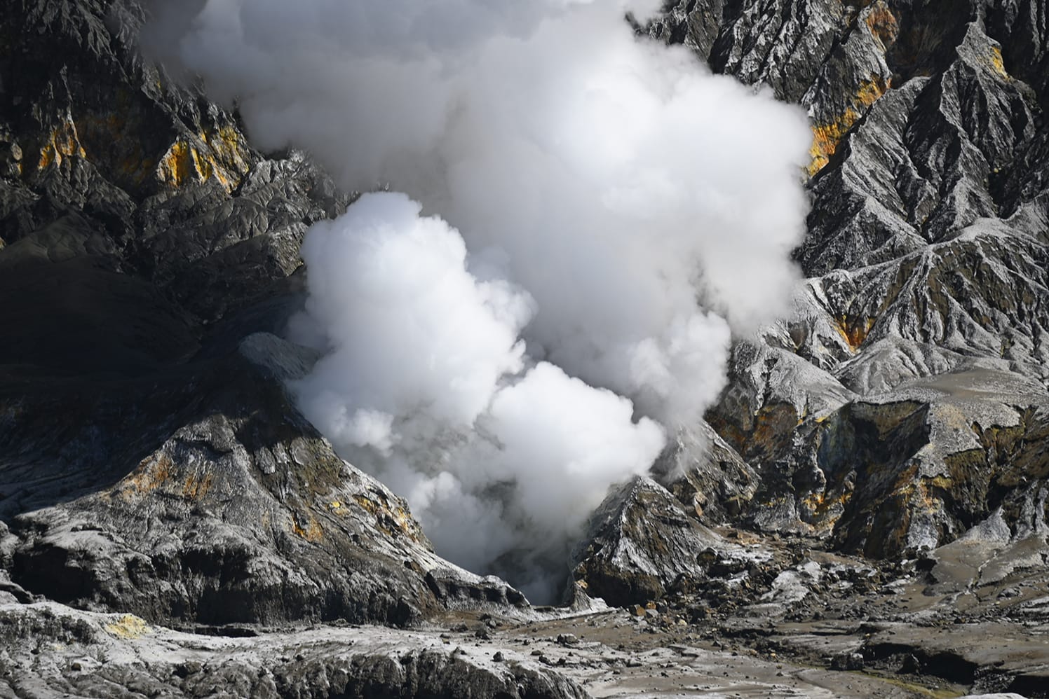
During these eruptive episodes, there have been periods of small eruptions that emit ash into the atmosphere and are transported downwind of the island. The ash in these emissions is very fine and it is usually carried away by the wind and remains airborne. Some of the eruptions have produced larger particles of ash that settle closer to the volcano. The volcano is 50 kilometres offshore from Whakatāne, and there have not been any significant ash impacts on the mainland during this eruptive episode.
Scientists also set an Aviation Colour Code (ACC), which tells the aviation sector about volcanic activity and the potential presence of ash in the atmosphere. GeoNet works closely with the Volcanic Ash Advisory Centre (VAAC) at MetService, Civil Aviation Authority, and Airways NZ to help keep people safe from airborne volcanic hazards like ash or gas. Ash in the airspace near local airports from some of the recent activity has disrupted flights from time to time. They have also worked with the regional harbourmaster when any volcanic hazards could impact mariners.
■ What’s below Whakaari/White Island?
Below the volcano there is a complex magma (molten rock) storage system, see graph above.

Research tells scientists deep magma feeding the volcano is sitting about 5-7km depth, and unrest or activity increases when some of this magma rises to shallower depths, less than 1km).
As magma rises to shallower depths, the output of heat and gas increases at the surface and our team measures this to understand what the volcano is doing.
At the moment, the team measures these during gas flights from fixed-wing aircraft, or helicopter-based observation and thermal infrared temperature checks.
Satellite data can also tell if there’s a significant gas output from Whakaari/White Island. New Volcanic Activity Bulletins are often issued after these flights, updating the status of activity at the volcano.
The graph at bottom right, shows temperature and gas measurements since January 2023. It shows volcanic activity clearly increased in early 2024.

■ Volcanic activity visible from the mainland
Eastern Bay residents are familiar with seeing steam and gas plumes above Whakaari/White Island. On a clear, cold day, atmospheric conditions make these plumes appear larger. Similarly, ash eruptions and emissions are often visible from the mainland too. Images from our volcano camera at Whakatāne show different plume sizes and colours.
Ash emissions and eruptions are typically darker in colour, and locals may sometimes see ash ‘falling out’ of a plume being carried away downwind. As mentioned earlier, it is uncommon for anyone on the mainland to be directly impacted by the current level of activity. If a larger eruption should occur or the wind is blowing straight towards the mainland, very fine ash deposits and gas smells may be noticed.
■ Research into Whakaari/White Island
Earth Sciences NZ has a range of research underway into Whakaari/White Island, and the eruption potential of all our volcanoes.
The Beneath the Waves programme is specifically looking into the hazard posed by nearshore volcanoes Tūhua/Mayor Island and Whakaari/White Island.
The team has just published a StoryMap to share more about these two volcanoes in an interactive way, with 3D models and detailed land and sea data.

■ What is likely to happen in the future?
The documented and oral history tells us that Whakaari/White Island is a frequently active volcano.
The volcano has been active for a very long time, preceding European records that start around 1820. The most intense period of activity occurred between 1975 and 2000.
These observations and new sea core data (as part of the Beneath the Waves programme) confirm that the volcano is highly active, but mostly produces small eruptions that affect the island and nearby ocean, rather than impacting tens of kilometres from the volcano.
Based on that history and current monitoring information, the volcano is likely to continue with this type and size of activity.